


SityTrail - G3- Prelenfrey - Col Vert

rolland-a
User
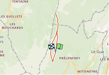

Length
9.6 km

Max alt
1746 m

Uphill gradient
522 m
Km-Effort
16.5 km

Min alt
1286 m

Downhill gradient
525 m
Boucle
Yes
Creation date :
2023-10-04 20:03:00.912
Updated on :
2023-10-04 20:07:25.232

FREE GPS app for hiking
 SityTrail
IGN / Geographical institutes
SityTrail Plus
The world is yours!
About
Trail of 9.6 km to be discovered at Auvergne-Rhône-Alpes, Isère, Le Gua. This trail is proposed by rolland-a.
Positioning
Country:
France
Region :
Auvergne-Rhône-Alpes
Department/Province :
Isère
Municipality :
Le Gua
Location:
Unknown
Start:(Dec)
Start:(UTM)
704668 ; 4988482 (31T) N.
Comments